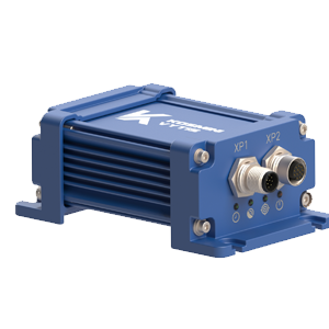


Kosminis Vytis introduces the Single enclosure GNSS/GNSS+INS receivers designed to expand navigation and orientation capabilities for moving objects.
Kosminis Vytis offers multi-constellation multi-frequency the Newton receivers series in multiple hardware and software configurations.
The Newton series includes: Newton-1, Newton-2 and Newton-3 lines, each of which differs in the number of GNSS antenna inputs tailored to different requirements and applications. These receivers are equipped with the high precision high accuracy positioning technologies to provide accurate and reliable data. The Newton(s) can be supplemented with MEMS to implement Inertial Navigation System (INS). The use of the inertial sensor data fusion algorithms with GNSS data allows to determine the moving object orientation and position during short GNSS
outages (dead reckoning functionality).
For integration into existing equipment, IP67 (enclosure) or OEM version are available (without enclosure).
The delivered package includes all necessary cables for quickly connect receiver(s) to peripheral devices (PC).
GUI provides a software tool for easy setup, configuraion, and data logging or viewing
GNSS measurements and code and carrier phase preudoranges, SNRs, Doppler.
Raw IMU data are raw accelerometer, raw gyroscope, temperature.
Autonomous mode is a basic method of GNSS positioning, also known
as standalone, absolute or SINGLE mode for Position, Velocity, Time (PVT)
calculation. While using this method, the PVT (navigation solution) is obtained
without usage of any external data (sources of augmentation or correction).
So, autonomous GNSS does not depend on receiving data via secondary data
channels, and from this point of view, is reliable and more accessible.
SBAS mode allows improved the performance of GNSS receivers by
regional Satellite Based Augmentation Systems (WAAS, EGNOS, GAGAN, MSAS, SDCM
and other SBAS-compatible services).
PPP mode is a high accurate positioning mode. Current version of
RTCM-SSR corrections supports so-called floating PPP, i.e. PPP with float
ambiguities. The typical convergence time is between 20-35 minutes. PPP mode
requires the use of dual-frequency measurements for estimation ionospheric
delay, thus the use of dual-frequency antennas is a must for using PPP mode.
The PPP convergence time depends on the quality of SSR corrections, satellite
geometry, atmospheric conditions. The current version of RTCM SC-104 standard
supports only GPS and GLONASS navigation systems.
RTK rover mode is a differential positioning mode that requires a set
of measurements received from the reference station (base station). Building
the differences of measurements between the rover receiver and the reference
station allows the rover receiver to effectively decrease the influence of the
delays associated with ionosphere and troposphere as well as to get rid of the
error related to satellite clocks. The position accuracy achievable by the
receiver(s) depends on the baseline length, quality of GNSS measurements
received from the reference station, atmospheric conditions, multipath
environment etc.
RTK base mode assumes generation of GNSS measurements along with
information about coordinates of the reference station and antenna type. In RTK
base mode, the reference station generates the following RTCM messages: MSM7,
1005/1006, 1007/1008, 1230.
Multi-constellation and multi-frequency receivers are capable of
calculating PVT by receiving satellite signals broadcast by multiple GNSS in
multiple frequency bands.
The use of multi-frequency receiver is the most effective way to eliminate ionospheric
delay in position computation.
Kosminis Vytis’ multi-constellation receiver(s) has access to signals from
GPS, GLONASS, BeiDou, Galileo and NavIC constellations as well as to SBAS
(EGNOS, WAAS, GAGAN, MSAS etc.). The use of several constellations leads to the
fact that a larger number of satellites are visible, i.e. If the signal is
blocked due to the operating environment, there is a high probability that the
receiver can simply pick up a signal from another constellation, ensuring
continuity and reliability of the GNSS solution.
Newton(s) simultaneously uses all supported GNSS in the navigation solution
and raw measurements collection, additionally allowing the user to
enable/disable GNSS constellations for tracking (user selectable GNSS constellations).
Inertial Navigation System (INS) is used to calculate the Position,
Velocity and Orientation of a platform (object).
The Kosminis Vytis’ INS includes two main components: Inertial Measurement
Unit (IMU) sensor and Computational Unit. The IMU is a sensor based on a
microelectromechanical system (MEMS) consisting of a 3-axis accelerometer and a
3-axis gyroscope. Computational Unit provides the processing of raw IMU data.
These relative measurements (INS) can accumulate drift errors over time.
Therefore, INS is combined with GNSS (GNSS+INS) to provide reliable, highly
accurate and high update rates positioning and orientation (attitude) in the
most challenging environments even during GNSS outages.
In the Kosminis Vytis’ GNSS-aided INS receiver(s), the GNSS data and IMU
data are fused by an Extended Kalman Filter (EKF) using a loosely coupled
integration algorithm.
Initialization Methods are available (user-selectable):
– coordinates are from own antenna, velocities are considered
equal to zero, roll and pitch are from accelerometer, the course (yaw) will
determine itself in the process;
– coordinates are from own antenna, velocities are considered
equal to zero, roll and pitch are from accelerometer, the course (yaw) is given
by the user;
– all parameters are derived from the user command.
Inertial receiver(s) setting up is significantly simplified with the Lever
Arm functionality.
You’ve been subscribed!